Tag Archives: #nationalparkweek

Denali National Park & Preserve

National Park Week, Final Day; Today’s Park Theme: B.A.R.K. Ranger Day

Denali and the Alaska Range, view from the south

I think it’s safe to say that I have visited Denali National Park more than any of the others. Of course, it’s only a two hour drive away. Denali is a gem of a Park, and its Mountain and namesake is the crown jewel. Discussions for the area to become a National Park started as early as 1906, and by 1915 there was a solid plan and momentum for the idea. The naming of the Park was contentious from the very beginning, and that should be the subject of a future blog post. Alaskans and Park proponents who had actually visited the area wanted to see the Park named Denali, which was the Athabaskan word for the Mountain. The powers in Washington DC, particularly  Thomas Riggs of the Alaska Engineering Commission, disagreed. The new park would be named Mount McKinley National Park, a decision that Alaskans would fight for decades until it was finally officially renamed Denali National Park in 1980.

A view along the Park Road

At first the new national park was accessed by the Alaska Railroad, which ran between Seward on the southern coast and Fairbanks. The Denali Highway was opened in 1957, giving road access to the Park from the Richardson Highway, which runs between Valdez on the coast and Fairbanks. It wasn’t until 1971 for Anchorage to have direct access to Denali with the building of the Parks Highway between Anchorage and Fairbanks. The Denali Park Road starts at the George Parks Highway, and travels west into the Park for 92 miles. The road ends at the historic mining community of Kantishna.

Teklanika River

There are several trails for hiking in Denali NP, but like the Wrangell-St Elias, this is wilderness, and most hiking is off trail and across country. River crossings are common, and seeing wildlife is (practically) guaranteed. I have one friend who is so wildlife viewing challenged, that other than rabbits and ravens, nothing will show for him. I add the “practically” for those in that exclusive club with my friend in NY.

Caribou in Denali

For the rest of us, wildlife viewing in Denali NP&P is a smorgasbord. I have never been in the Park without seeing caribou and moose, and always grizzly in the summer months. I once took my Dad to Denali and we rode the school bus to the end of the Park Road. While stretching our legs at a rest area, I spotted a wolf sauntering along a river bed, and pointed it out to my Dad and another gentleman who was on the bus with us, and they watched it through my binoculars until we had to board again. I ended up getting scolded by everyone else who was on the bus, because I didn’t hunt them all down and show them the wolf too. Beware of the bus etiquette.

Alaskan Standoff: Grizzly Bear vs Bull Caribou

Denali is a special place in the winter, and I’ve enjoyed snowshoeing the trails and even the roads with the crowds of summer a very distant memory. Dog mushing is a very common activity in the winter, either with your own team, or riding along with a guide. Cross country skiing, snowshoeing and winter camping are the most common wintertime activities. It is a very beautiful, and quiet, winter wonderland. I searched and searched for winter pictures, and I could not find where I stashed them so that I could easily find them again. I will have to go back to create some more.

Denali Park Kennels

Dog mushing teams have been a part of Denali Park since 1922. The Park still maintains and works a team of sled dogs. In non-Covid years, the kennels can be visited, and the rangers give some pretty cool demonstrations. Plus, these dogs are just a lot of fun to hang around; Alaskan sled dogs have developed their own unique personalities, and they love to show them off. Driving the Park Road, you will often see the dog handlers walking the sled dogs, so watch for the signs.

The Replacements: Denali Park Puppies

Denali National Park & Preserve covers 4,740,911 acres and received 594,660 visitors in 2018.

Find your Park! And pet a Puppy!

Images of the Denali Park Dog Team and Puppy Patrol courtesy of NPS/Denali Dog Ranger Division


Death Valley National Park

National Park Week, Day VIII; Today’s Park Theme: Junior Ranger Day

Entering Death Valley

The “Hottest, Driest and Lowest”:

I have been lucky enough to visit Death Valley a few times. I did skip this Park when I was traveling in the air-cooled VW, but the Land Rover has been here a couple of times, and I once tortured a rental car during a visit to Death Valley in August. I drove the rental here from Las Vegas after a wedding just to see how hot it would get. I watched the car thermometer hit +123F. So my personal variance is -63F to +123F degrees.

The Devil’s Golf Course

It was not over 100 when I drove the Rover through. In fact, I remember it being quite nice, weather-wise. Very cool at night, and above 80F during the day. At one campground, it absolutely poured rain. Gullies filled quickly, but I had the rooftop tent. I could see the rain coming across the desert from my site, and quickly popped open the tent, threw what I needed up into it, then set up a chair under the canopy to eat dinner. The rain came down in buckets, and the wind picked up, so I moved my chair into the back of the Rover, and watched the proceedings. Across the campground, I could see two poor souls battling a ground tent. They should have just waited out the rain, but they stuck to their guns, and kept on with the tent. It took forever, to the point that I was suffering just watching the show. The tent had to be as soaked inside as they were standing out in that downpour.

Somewhere along Artist’s Drive

Death Valley was first established as a National Monument in 1933, becoming a National Park in 1994. The Park encompasses 3,373,063 acres across the states of California and Nevada. Badwater Basin, which I have done some hiking in, is the second lowest point in the western hemisphere at 282′ below sea level. Telescope Peak is the Park’s highest point at 11,049 feet above sea level.

Walking out in Eureka Sand Dunes

The Valley is a hot and dry place to explore, so bring plenty of water. Hot weather tip: Any water jug left in your vehicle will quickly reach the temperature of the vehicle’s interior. So, if you don’t want to brew a cup of tea after a day out hiking, try to keep that jug outside and in the shade.

The highest temperature ever recorded on Earth happened at Furnace Creek in Death Valley in 1913: 134F. That is a scorcher. The record low for Death Valley is 15F. Practically balmy when you think about it. Badwater gets on average 1.5 inches of rain a year.

Scotty’s Castle

I did stop by Scotty’s Castle on one visit. It was named after a local gold prospector, Walter Scott, who neither lived in, nor built, the residence. Construction began in 1922, and the building costs were somewhere between $1.5 – 2.5 million. The history here is intriguing, and involves investments in nonproductive mines, as well as mistakenly building on government property. The stock market crash of 1929 also played a part. When the owners passed away with no heirs, the National Park Service bought the “castle”. It can be toured, during non-covid years, and I thought the tour was well worth the fee.

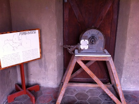
The castle’s water source was a nearby natural spring, which also powered a Pelton wheel which powered the house as well. Death Valley Scotty may not have lived in the castle bearing his name, but he is buried on a hillside overlooking the home. The family’s pet dog is buried next to him.

The Pelton Wheel

There is so much to see at Death Valley. The famed Racetrack is one location, but I did not witness any racing rocks, still it’s a phenomenon that is cool to document. The Eagle Borax Works, or more commonly known as the Twenty Mule Team of Borax fame has some ruins out in the Park, and there are several CCC works still being used. There are trails, and wildflowers galore when it rains, natural springs and arches, and petroglyphs out at Mesquite Springs.

Death Valley saw 1,678,660 visitors in 2018.

Go Find Your Park!

Guadalupe Mountains National Park

National Park Week, Day VII; Today’s Park Theme: Friendship Friday

Guadalupe Mountains, Texas

My visit to Guadalupe Mountains was purely spontaneous. The trip goes all the way back to the Beetle Roadtrip, when I drove Coast to Coast to Coast in a 1973 VW Beetle. Those blogposts are lost to history, but it was a 4 month road trip, covering some 12,000 miles.

I had just come out of Carlsbad Caverns and was planning on camping out. Tent sites at White City were highway robbery, and I refused to pay the extortion simply out of principle. A woman in a souvenir store motioned me over to her when I was walking back to my car. She suggested, if I “don’t mind going a bit out of the way, drive out to Dog Canyon Campground in the Guadalupes”. Surprisingly, I didn’t mind at all, so the Beetle and I drove north, then west, and then dropped down into Texas and Dog Canyon.

Sitting Bull Falls

Along the way, I found a side track to Sitting Bull Falls in the Lincoln National Forest. There is a short trail from the parking area to the 150′ waterfall with a natural pool below. There are also several hiking trails around the area. I met a group of Harley riders when I was there, and like everywhere I went, several of them had to tell me about the Beetle they used to own.

Dog Canyon Campground

Dog Canyon is off the beaten path, but I don’t remember the old Bug having any clearance issues, but we did lose a race to a roadrunner. By now, I was confident in that little car going through most anything I asked it to, after having already crossed some streams, and the general mucking about the countryside I put it through. I have heard that this campground can get quite busy, but there was only one other site occupied for my entire stay there. Two men had the other site, and they played their guitars all day, and well into the night. I found the music to be a nice surprise, and they were both pretty good, although I remember one to be much better than the other. The sound of guitars sure beat the sound of generators.

Hiking the Guadalupes

Guadalupe Mountains National Park was established in 1972 and encompasses 86,367 acres. The Park protects world’s most extensive Permian fossil reef. The Permian period occurred 251-299 million years ago, when the continents were locked together in the large land mass now called Pangea. The area of what is now Texas and New Mexico was on the western edge of this land mass. An inlet from the ocean existed in the area of what is now the Guadalupes, and a reef was formed. Within the Guadalupe Mountains is the remnants of this reef. The fossilized marine life from this era can be easily found in the limestone. On one hike, I met a ranger and asked about the fossils, he walked me over to some exposed rock right away, and there were several different species, fossilized in the rock face.

There are some incredible trails in the Guadalupes

I hiked for several days, and at one point picked up a free backcountry permit and disappeared for a few days more. I brought a thin sleeping bag and a lot of water, but no tent. The warm weather and the complete lack of bugs of any kind was a wonderful experience. One night, while laying on my back, looking up at the Milky Way, a meteor streaked across the sky. To this day, it remains the brightest one I have ever experienced. The entire mountainside was lit up, almost as light as day, but a more “artificial” light, then it dissipated. I was so stoked, I didn’t sleep for hours, as I couldn’t wait to see another.

El Capitan as seen from the trail

I have incredibly fond memories of my time in the Guadalupes. There were no shortage of trails, water was available at campgrounds, visitor centers and ranger buildings. A hike I wish I had done, but always expected I’d come back to do, was the climb to Guadalupe Peak, which is the highest point in Texas at 8751′.

Evidence points to these mountains being inhabited for the past 10,000 years, so there is no shortage of history, both geographical and human.

Guadalupe Mountains National Park saw 172,347 visitors in 2018.

Find Your Park!


Earth Day 2021


National Park Week, Day VI: Everglades National Park

The view from Flamingo; Camera: Widelux, 35mm

The Everglades may be the only National Park I’ve had to fast talk my way into. They were having wildfires when I drove down from Tampa one spring. I had seen the warning signs, but kept going until I came to a roadblock. Off to my left, I could see some smoldering, but as far as wildfires go, it looked pretty tame. The ranger hemmed and hawed at me, but I persisted. Eventually I said, “Look, I’m from Alaska, we deal with this all the time, and that doesn’t look like Armageddon out there.” The ranger said I could go forward, but I had to commit to staying at Flamingo for several days, and not even drive back to the roadblock. I made the deal, and released the clutch.

Looking out across the river of grass

It was dry, and it was hot during the day, and the mosquitoes still gave Alaska a run for the money. It was hard not to be impressed by the little bloodsuckers tenacity. I was also impressed by the vultures. It isn’t every day you see a string of them with their wings fully extended drying in the sun, when you climb out of the tent in the morning.

Map of the Everglades: Before and after

Everglades National Park covers 1,508,976 acres, which is 20% of the size of Florida’s original Everglades. It is the largest subtropical wilderness in the United States, and the largest wilderness of any type east of the Mississippi River, and the third largest National Park in the Lower 48.

The Everglades were a vast network of wetlands, interspersed with forests. Water flowed from Lake Okeechobee through the Everglades and into Florida Bay. It was the first Park created to protect a fragile ecosystem.

A hike out to the Gulf to see the Mangroves

I did a lot of hiking during my time in this incredibly unique Park. Many trails led me out to the Gulf Coast, with the final section through the dense mangrove forests.

Another incredible way to see the Everglades would be the Canoe & Kayak Trails through the Park. There are numerous water trails for either a canoe or kayak, and trips can be fully guided or self-guided. Many campsites are on raised platforms. Any return trip to the Everglades for me, would have to include some of the water trails.

Three alligators lounging on the waters edge.

For wildlife, I mostly saw all sorts of birds, from great blue herons and white ibis, to osprey and brown pelicans. Over 360 species of birds have been seen in the Everglades. I was surprised to learn that the black vulture was a bit of a vandal. It seems that greeting people when they climb out of their tent in the morning was not their official duty in the Park. It turns out that they enjoy tearing the rubber off of vehicles. I’m not totally unfamiliar with the habit, as I’ve seen ravens steal wiper blade rubber, but the vultures seemed to be particularly vengeful. To the point, that people were actually renting blue tarps and bungee cords to deter the vultures. I chose not to wrap the car with a blue tarp, and honestly had no trouble. They did eyeball the Nissan from a distance, which I could live with.

The Everglades has two distinct seasons: The Dry Season, which is roughly November to March, and the Wet Season which runs April to November. I was told that the Wet Season can be buggy, and I was there before the Wet Season began, and I can tell you that it was quite buggy once the sun started to set.

Each year brings over one million visitors to Everglades National Park.

Happy Earth Day! Go find your Park!

Kenai Fjords National Park

National Park Week, Day IV; Today’s Park Theme: Transformation Tuesday

Map of Kenai Fjords National Park

Kenai Fjords: Where Mountains, Ice and Ocean meet.

Kenai Fjords was first designated a National Monument in 1978. With the passage of ANILCA, the Alaska National Interest Lands Conservation Act in 1980, Kenai Fjords officially became a National Park.

Exit Glacier

Kenai Fjords encompasses 669,984 acres, which includes the massive Harding Icefield, which is the source of at least 38 glaciers.

Climbing up to Exit Glacier; Camera: Leica M3, Film: TMax100

Exit Glacier and the Harding Icefield can be reached from the community of Seward. It’s a short drive from town to the visitor center and trail head. The short and relatively easy trail takes one to the foot of the glacier. Exit is retreating at a pretty good clip, and is now losing ice during all seasons.

The Harding Icefield

The Harding Icefield covers over 700 square miles, and that does NOT include the 38-40 glaciers that spawn from it. The hike past Exit Glacier to the icefield can be described as strenuous, but the view, when clear, is absolutely amazing.

An emergency shelter surrounded by the Harding Icefield

Harding Icefield is one of four remaining in the United States, and the largest that is contained completely within the country. It receives, on average, 400 inches of snow each year.

Bear Glacier as seen from Resurrection Bay

Much of the Park is only accessible by water, and sea kayaking is a very popular activity. There are many tidewater glaciers that can be reached from Seward.

Kayakers dwarfed by Aialik Glacier

Two glaciers that I have visited from Seward are: Bear, which is the longest glacier in the Park, and Aialik Glacier, which is a bit more impressive from the water. Bear has receded to the point, that a lake now exists between the ocean and the glacier. The lake is often filled with small icebergs, which makes kayaking interesting. Aialik is a giant ice wall from the water’s surface.

Kenai Fjords National Park received 321,596 visitors in 2018. It is the fourth most visited Park in Alaska, and the closest to the city of Anchorage.

Find your Park!

General Grant National Memorial

National Park Week Day III; Today’s Theme: Military Monday

General U.S. Grant National Memorial

I was on my Amtrak Railpass tour of the Lower 48, when I was lucky enough to be invited to spend some time in New York City. While exploring the campus of Columbia University, I decided to walk down to General Grant’s mausoleum.

Let Us Have Peace

General Grant died of throat cancer on 23 July 1885. The mayor of NYC at the time, William Russell Grace, immediately offered a place in his city for the mausoleum. Grant himself, had only one request: That he should lie beside his wife Julia when she passed. That left out the military cemeteries, which did not allow women to be interred at that time.

Memory of the country’s Civil War was still fresh, and any funding need for a memorial to the General who ended the war, was met with enthusiasm. Not to say that there wasn’t controversy. Washington D.C. felt that they should get his memorial, and there were design competitions and delays. Still, construction began in the summer of 1891, and Grant’s remains were transferred to the red granite sarcophagus on 17 April 1897. The monument was dedicated ten days later on the 27th, which would have been Grant’s 75th birthday.

The 8.5 ton red granite sarcophagus, the final resting place of General Grant and his wife Julia

Julia Grant would die five years later in 1902.

The National Park Service assumed authority over the tomb in 1958. In 1991, efforts were made to bring attention to the deteriorating condition of the mausoleum. This was not the Park Service’s finest hour. A Columbia University student, Frank Scaturro, who was also a volunteer at the Grant Memorial, tried in vain to bring attention to the lack of maintenance at the tomb. Graffiti and vandalism plagued the Memorial, and the building was in very poor condition. After two years of being ignored by the Park Service, Scaturro wrote a 325 page whistle-blower report to both Congress and the President.

In 1994, the U.S. House of Representatives passed legislation to  “restore, complete, and preserve in perpetuity the Grant’s Tomb National Memorial and surrounding areas.” The restoration of the Memorial was completed in 1997, and the site rededicated on 27 April 1997 – 100 years after the original dedication.

When I was there, the Memorial had a jazz concert playing nearby, and the grounds and Riverside Park were immaculate. It is a very peaceful setting above the Hudson River.

Approximately 80,000 people visit the Grant National Memorial in non-pandemic years.

Find your Park!

Wrangell-St Elias National Park and Preserve

National Park Week Day II; Today’s Park Theme: Volunteer Sunday

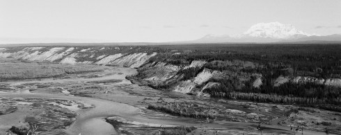
The Chitina River en route to McCarthy

Wrangell-St Elias may very well be my favorite road accessible park in Alaska. Denali is closer, and I visit it the most, but Wrangell-St Elias is a trip of its own. First off, it is the largest National Park at 13.2 million acres. It starts at sea level and rises all the way up to 18,008 feet with the summit of Mount St Elias, which is the second highest peak in the United States.

Mount Blackburn

Within Wrangell-St Elias is four mountain ranges: The Chugach, Wrangell, St Elias, and the eastern part of the Alaska Range. Mount Wrangell is one of the largest active volcanoes in North America, and nine of the sixteen tallest peaks in the U.S. are within the boundaries of Wrangell-St Elias.

If you prefer glaciers, Wrangell-St Elias has you covered with 60% of Alaska’s glacier ice within this park. It has the state’s longest tidewater glacier, North America’s largest piedmont glacier, and the world’s longest valley glacier.

The park offers an endless list of things to do. The hiking here is phenomenal, although established trails are few. The beating heart of this park is wilderness. I have seen the gamut of Alaska wildlife with Wrangell-St Elias.

The Kennecott Mine

The Edgerton Highway runs along the Copper River Valley to Chitina, where the McCarthy Road follows the old CR&NW Railway grade to the Kennicott River. For years, you had to stop there to take a tram across the river to the town of McCarthy and the mines of Kennecott. Today, the tram sits unused, and a walking bridge spans the river.

The Kennecott Mine and company town were named after the Kennicott Glacier, but they missed the spelling by a letter. It gets confusing trying to keep it straight. Copper ore was discovered here in 1900, and a rush soon started. Eventually, Kennecott would have five mines operating, but by 1938 operations had shut down. During that time span, the mines produced over 4.6 million tons of copper ore, and gross revenues of $200 million. I’m not sure what that dollar amount would add up to today. The Kennecott Mines are now a National Historic Landmark District.

McCarthy, Alaska in 1915
McCarthy Hardware in 2011

The population of McCarthy in 1920 was 127. By 2010 it had dropped to 28.

Some of the mines like Jumbo can be hiked to, and the green of copper ore can still be seen in the rocks around the area.

Fishing the Copper and Chitina Rivers is an Alaskan tradition, going back millenniums. Dipnetting for salmon is restricted to Alaska residents, but I can tell you that it is an adventure like no other.

If you want a park that you can disappear into, Wrangell-St Elias may just be the place for you. 2018 saw only 79,450 to the nation’s largest park. Like Alaska in general, that’s a lot of elbow room.

Find your Park!

Joshua Tree National Park

It is National Park Week, so we will revisit a few of the National Parks that I have been to. We are extremely lucky to have such a system in the United States: from Battlefields to Memorials, and Monuments to Parks and everything in-between, the National Park Service has it covered.

One of the best sites on WordPress, without exception, covering the National Parks, and all public lands is:

https://nationalparkswitht.com Check this very rewarding site out! You will not be disappointed. It is one of my favorite sites on this platform.

Today’s Park Week Theme: Park Rx Day

Entering Joshua Tree

The Day One Theme for National Park Week is Rx Day: Where being outdoors improves your mental and physical health. Anyone who has followed this blog for anytime would not be surprised to hear that I support that conclusion. As a dweller of the Far North, I find myself intrigued by the desert, and I have to admit that Joshua Tree is one of my favorite parks. Full Disclosure: I may say this all week long.

There is a simplicity to the desert that I find fascinating. Rarely have I found a crowd when I visit the desert, which suits me just fine. I have been to Joshua Tree several times: Once on the Beetle Roadtrip, at least once during a Land Rover Roadtrip, and once when I was on an Amtrak Railpass crisscrossing the country. Each time, I found my visit to Joshua Tree to be soul cleansing, and I do not use that term lightly. Even though, I may not have known I needed it, that is exactly what I found as I hiked the trails of this magnificent National Park.

The Land Rover meets a Joshua Tree

Joshua Tree was declared a National Monument in 1936, and it wasn’t reclassified as a National Park until 1994. Today, the Park encompasses 790,636 acres, including parts of two deserts: The Mohave and the Colorado. In the open areas of the Mohave Desert thrives the Yucca brevifolia, also know as the Joshua Tree, from which the park gets its name.

Hiking Joshua Tree

I spent much of my time hiking Joshua Tree, and I do not remember ever coming across another hiker on the trails. I met people at other areas, like lookouts, etc, but on the serious trails I was alone with my thoughts and the wilderness. I was certainly helped out at times by a friend who was a park ranger, who could point me in the right direction, but I imagine that much was simply luck of the draw.

Hiking trail in JTNP

In the spring of the year, I found the park relatively green, but I still carried plenty of water, as temps did rise above what I am used to by noon. Still, I found the desert refreshing in a way that only someone who lives in a completely opposite environment can. I have found myself coming back to this park often.

Lost Palms Oasis

A popular hike is out to Lost Palms Oasis, which is approximately 7-1/2 miles roundtrip. Most of the hike was through hilly terrain with a drop down into a palm-filled canyon at the end. It was a beautiful hike, with what really is an oasis at the end. Well worth the effort, although this is hardly the only hike in the park worth sweating over.

The homestead at Keys Ranch

The park has a rich history of mining and ranching, and a good example of both is Keys Ranch. I took the tour on one of my visits, and as an end-of-the-roader myself, I really enjoyed it. The family had a rich history in the area, and had carved a unique, yet wonderful homestead out of the desert. If in the area, I really do recommend a stop at the ranch.

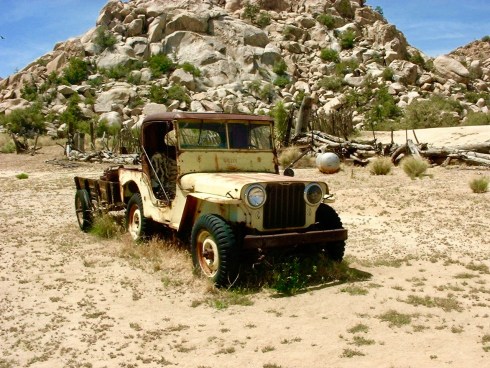
The Keys Ranch Willys Jeep

Any resident of Interior Alaska would sympathize with the ranch life out here. The ranger giving the tour took us through their “hardware store” of used parts sitting out in the dry air, ready to be put back into action. There is even a sawmill run by a FordAll tractor. A dam was built to collect what little water flowed from a creek, which allowed the family to prosper.

Gram Parsons’ Rock; RIP Grievous Angel

I should not perpetuate this story, as it will annoy my ranger friend, but how does one talk of Joshua Tree without mentioning Gram Parsons? I did my pilgrimage out to the Gram Parsons Rock, in spite of the annoyance it gave to others. Parsons, who was a singer and musician in bands such as The Byrds, The Flying Burrito Brothers, and others, was a huge fan of Joshua Tree back in the 1960’s and ’70’s, when it was still a National Monument. The cliff notes version of the story, is when Parsons overdosed in 1973, his friends knowing that Parsons wanted to be cremated within Joshua Tree NM, stole his body from the Los Angeles International Airport in a “borrowed hearse”. They then brought his body and casket to Cap Rock and attempted an unofficial cremation with five gallons of gasoline. Police arrived, and the friends escaped, only to be caught later. Since it wasn’t exactly a crime at the time to steal a dead body, they were charged with stealing the coffin and fined $750. Cap Rock, or what is now mostly known as Gram Parsons Rock, still brings mourners and fans of the influential singer/songwriter. I should note that it is the site of my very first selfie. One of a total of three. I should also note that Park Rangers are not overly fond of giving directions to the rock, even if you have known them since they first arrived in Alaska, back when they were a young Cheechako. Just saying.

One of my campsites in Joshua Tree

I have met many rock climbers within Joshua Tree, and have offered a few beers to some after their climb, after finding out they were camping near me. This park, along with Yosemite and Zion seems to be a magnet for climbers.
My favorite individual who I shared a camp with was an Argentinian. I had just traveled from Prudhoe Bay to Belize and back to Southern California, obsessed with driving to the tip of South America. My new friend from Argentina had beat me to it, and was driving north to Alaska from Tierra del Fuego in a mid-80’s Land Cruiser. He had spotted my old Land Rover first, as one does, when I was out hiking, and stopped by with a bottle of Argentinian Fernet. The next night, I went down to his campsite with a bottle of Scotch. We had a lot to discuss.

One never knows who you will meet when you are out & about in our public lands.

There were 2,399,542 visitors to Joshua Tree NP in 2020.